Adventure Guide
Mendocino National Forest

“One of California's most accessible national forests. Mendocino NF is an overlander's paradise packed with a dense network of soft-roading dirt trails and ridge-top drives that sees a fraction of the crowds you'll find in busier locations like the central and eastern Sierra.”
Vehicle Accessibility
AWD / Crossover
Good
Sprinter / Van
Good
Stock 4x4
Best
Modified 4x4
Best
Best Seasons
Spring
Good
Summer
Best
Fall
Good
Winter
Variable
Crowd Level
🌙 Dark Skies
No paved road crosses Mendocino National Forest. It's the only national forest in California you can't drive through on pavement, and that keeps the crowd thin. Most people who don't already know about this forest never find it.
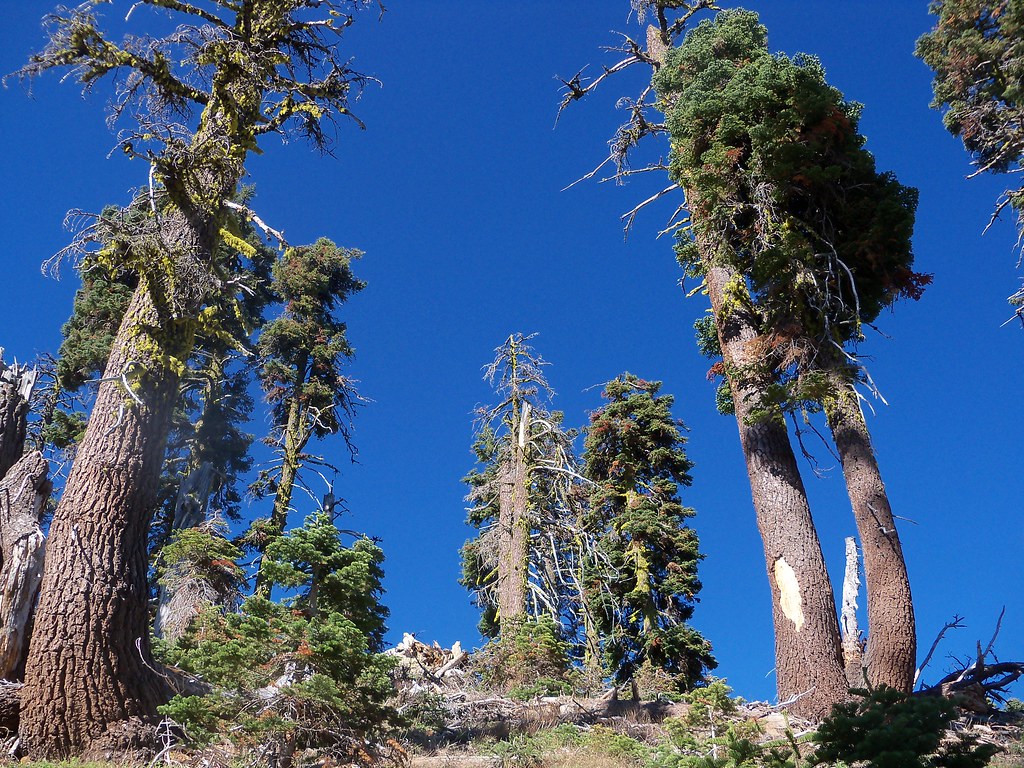
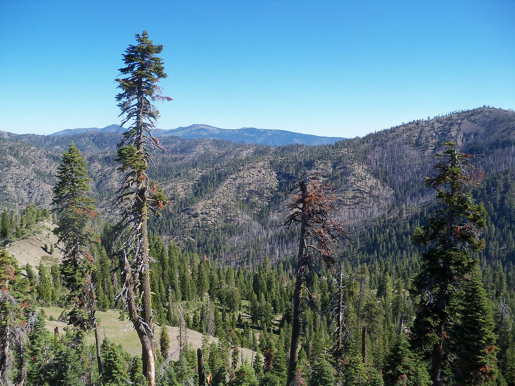
Lower elevations are dry oak savanna and rolling grass hills. Get up past 3,000 feet and it turns to ponderosa pine, then dense mixed conifer as you push higher. The ridges open up into long views across the Coast Ranges. The northern section, up around Hull Mountain and Anthony Peak, is properly remote for being two hours from the Bay Area.
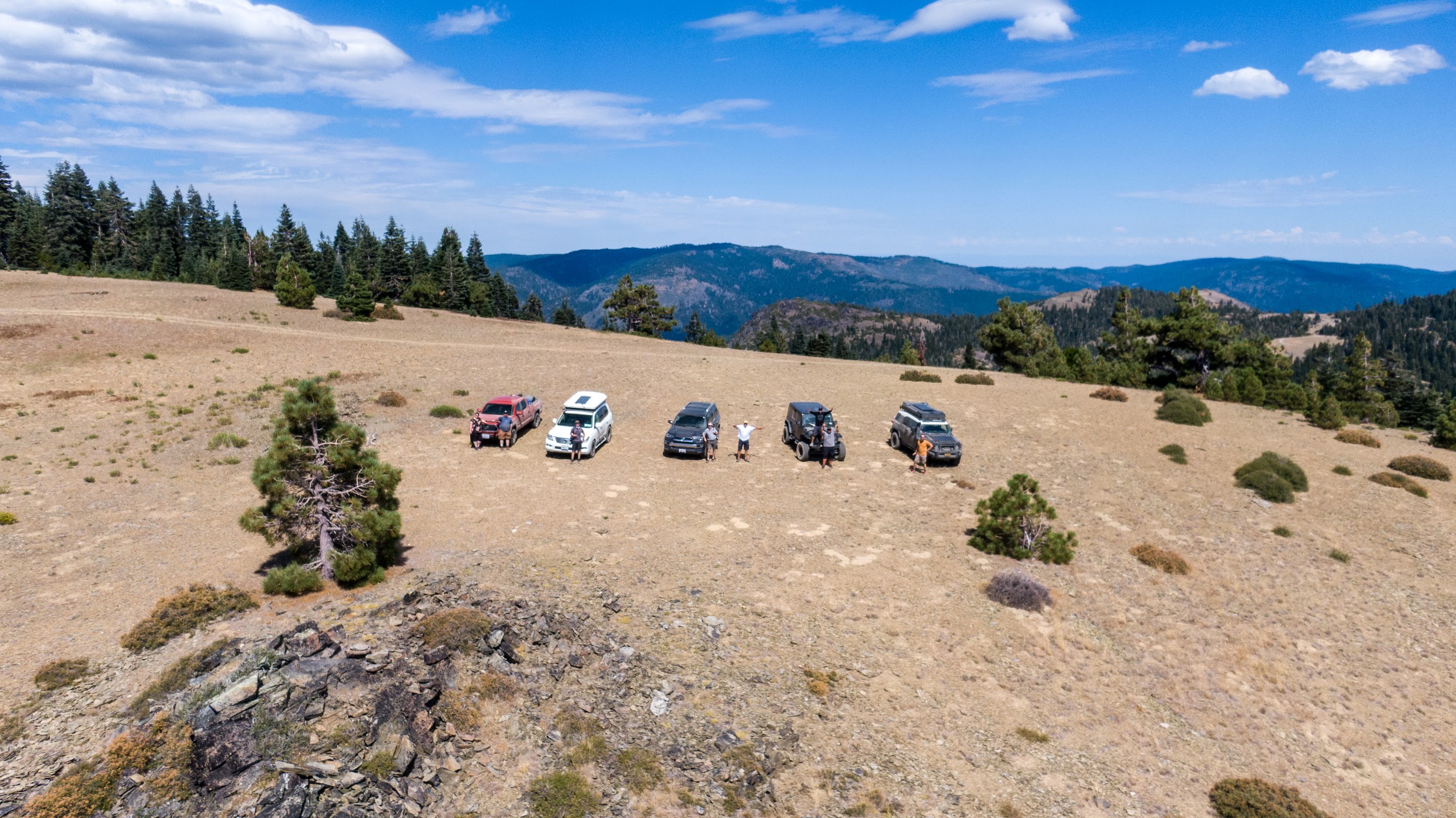
98% of the road network is unpaved but most of it doesn't need a 4WD. A stock Tacoma or AWD crossover handles the main corridors fine in dry conditions. If you're newer to backcountry driving, this is a good place to build confidence. There's enough road to explore for a week without doubling back on yourself.
Lake Pillsbury is the main hub, with drive-up camping on the water and no reservation required. Stonyford on the east side anchors one of the largest OHV networks in Northern California. Fuel stops: Upper Lake and Ukiah to the west, Potter Valley on the main entry corridor, and Covelo on the eastern side via Hwy 162. Covelo sits at the edge of Round Valley and has been home to the Wailaki and Yuki peoples for thousands of years.
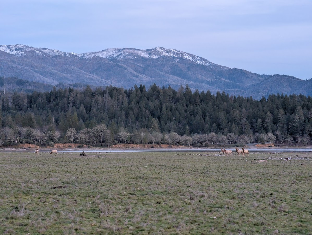
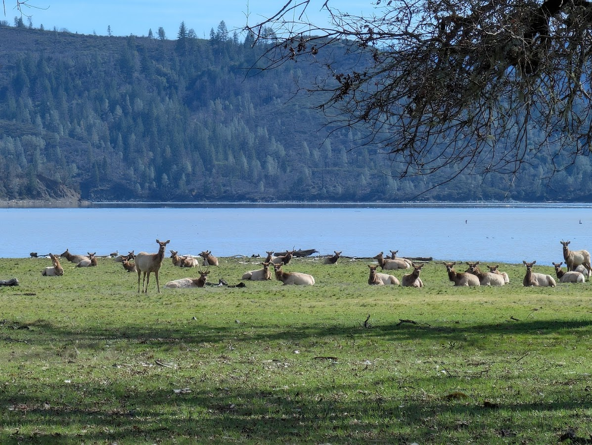
The Tule elk herd winters in Gravelly Valley and the Pillsbury Basin from October through March, regularly visible from the main road in the early morning. Kayaks and canoes launch directly from the Lake Pillsbury campground, and resident bald eagles hunt the water year-round. Below Scott Dam, the Eel River drops to a series of gravel bars accessible by 4x4 that most visitors never find. June through early July, before water temperatures climb, is the window for swimming and riverside camping.
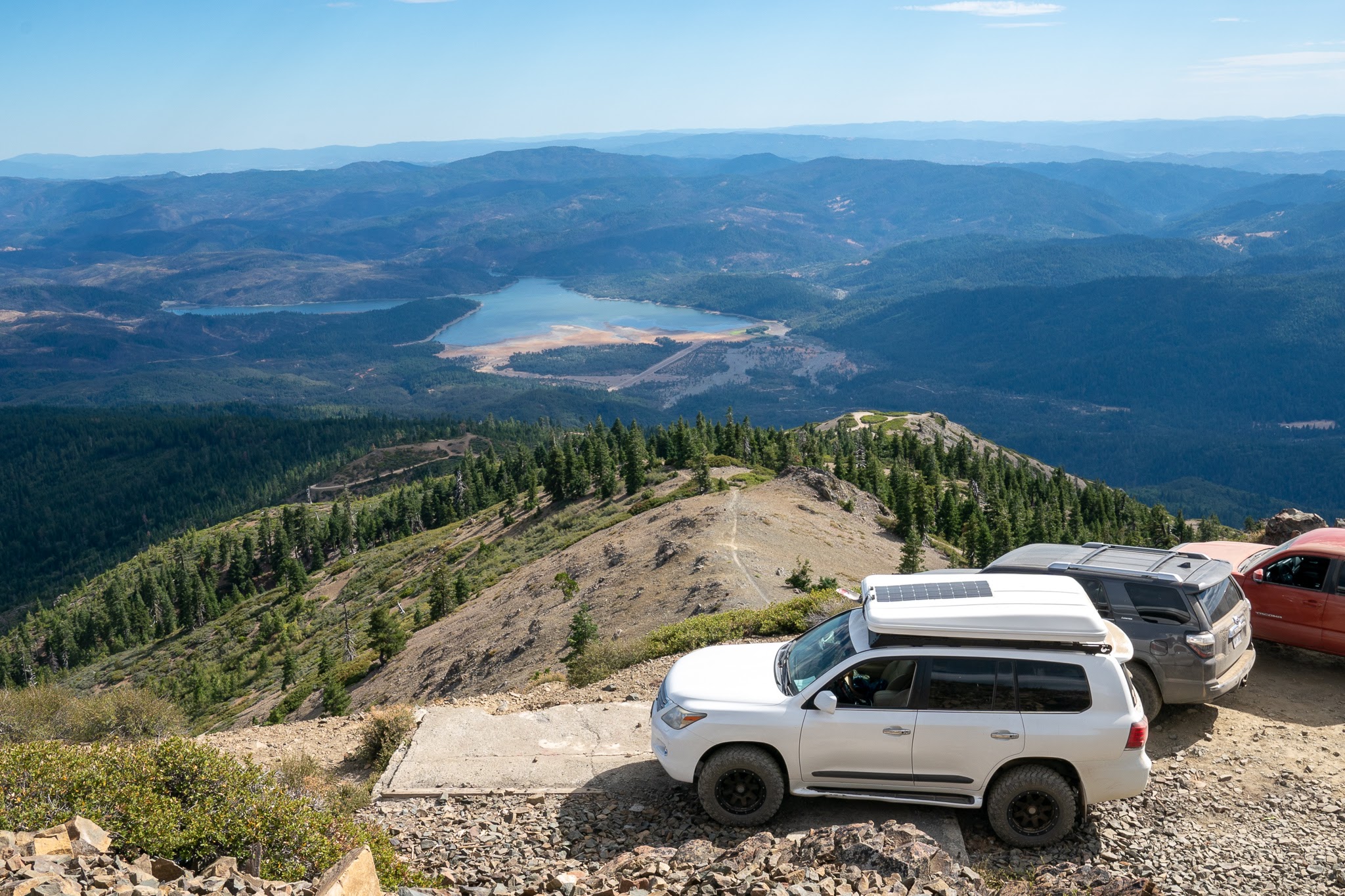
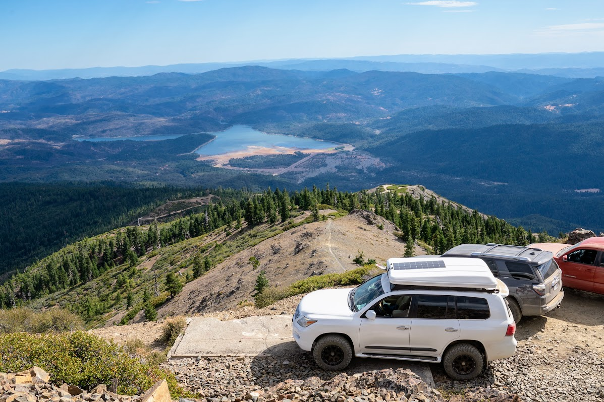
Hull Mountain at 6,873 feet and Anthony Peak at 6,954 feet are the two high-country destinations. Both are drivable on a stock 4x4 and both close with snow November through April. Anthony Peak is the last staffed fire lookout in the forest. On a clear day the view from either summit runs from the Pacific coast to the Sacramento Valley floor. After dark, both sit in a Bortle Class 2 zone, among the darkest skies in California.
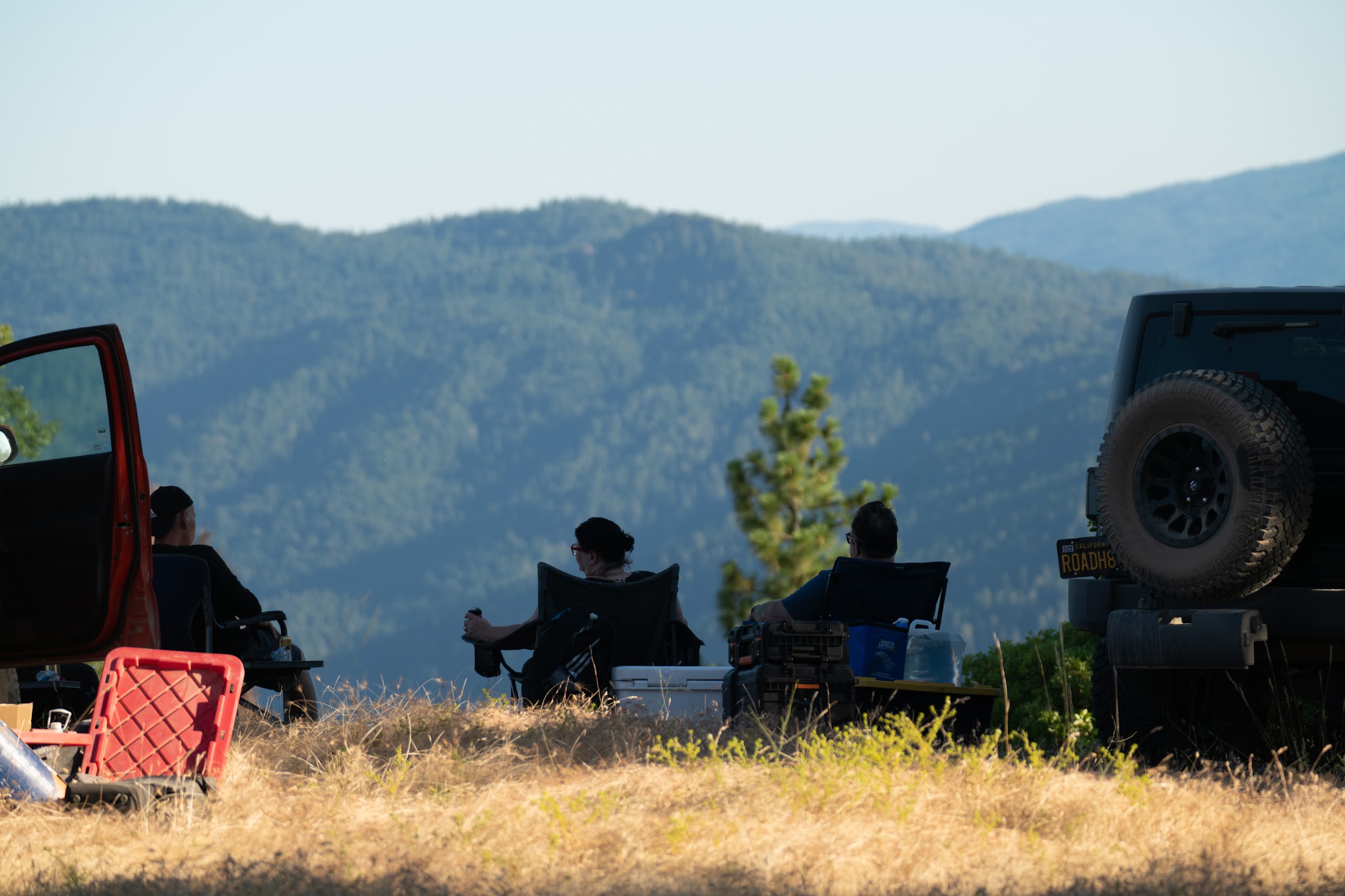
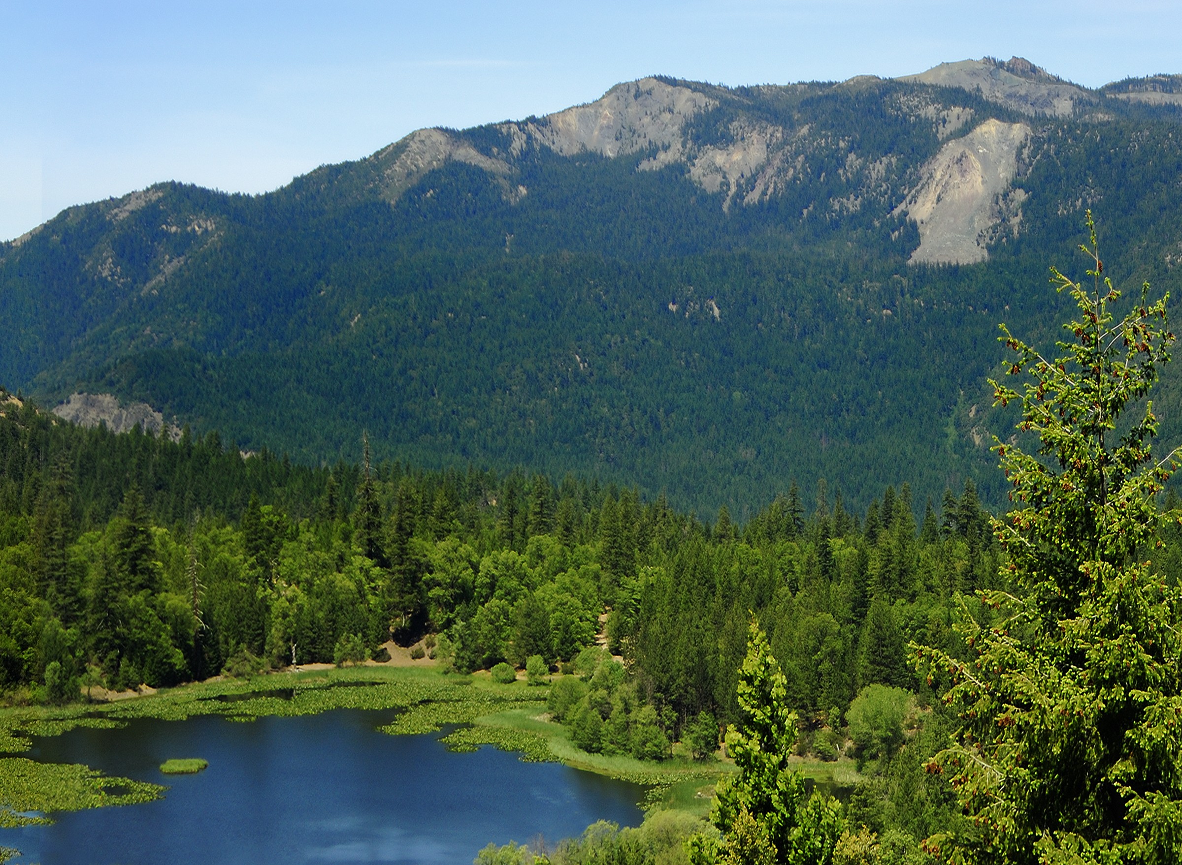
Lake Pillsbury Basin
Lake Pillsbury is the social hub of the forest and the first stop for most first-timers. Developed sites ring the lake with no reservation required; weekends fill early from Memorial Day through Labor Day, midweek is noticeably quieter. The Upper Lake OHV network stages here, so the crowd mixes tent campers, anglers, and riders depending on the day. Resident bald eagles hunt the lake year-round. PG&E submitted dam surrender paperwork to FERC in 2025, with removal targeted for 2028.
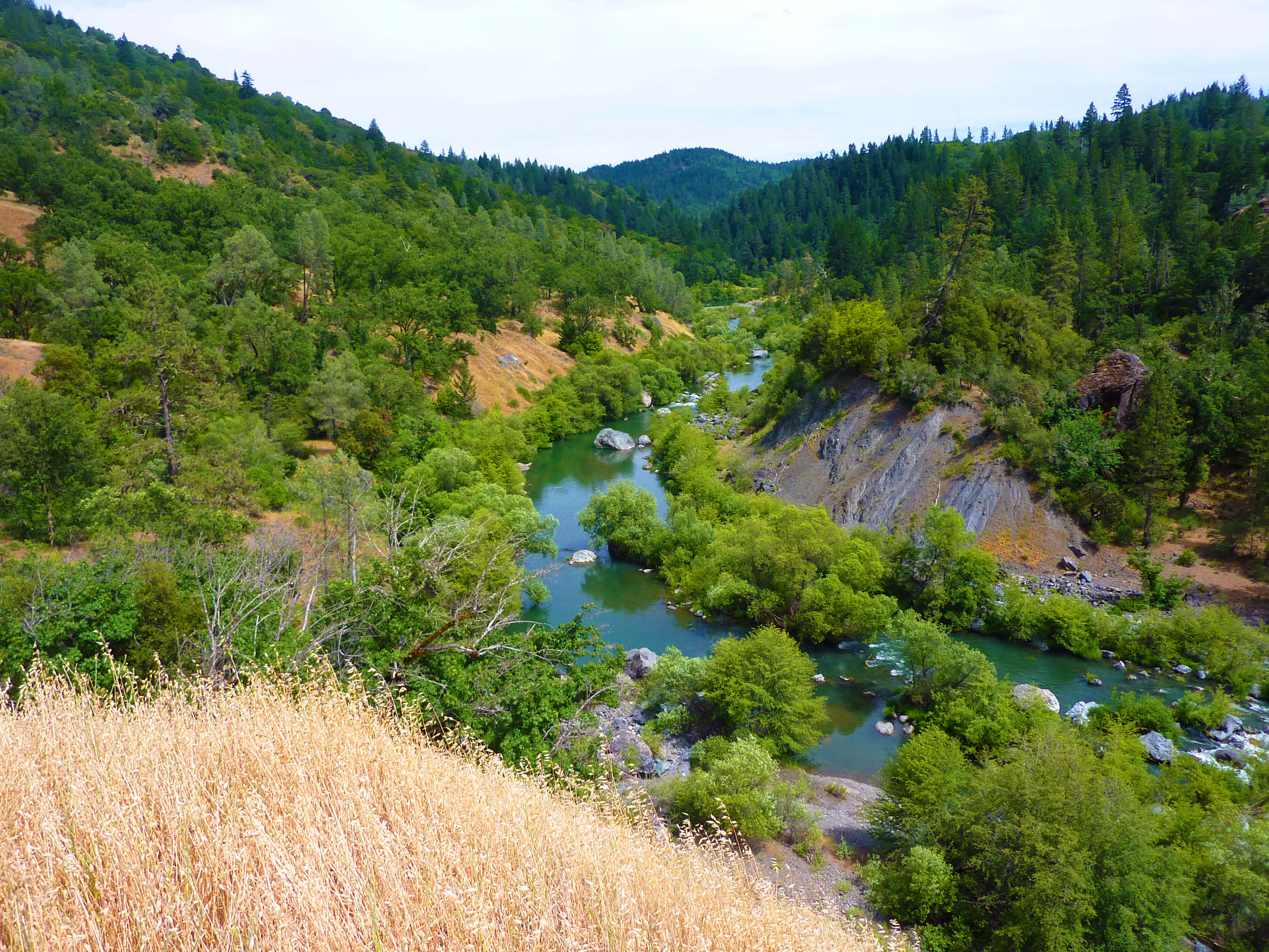
Eel River Corridor below Scott Dam
The stretch below Scott Dam pulls dispersed campers and swimmers from Memorial Day through Labor Day. Access requires a stock 4x4 down rough spur roads off M1. Weekend traffic has picked up in recent years. Go Tuesday through Thursday if you want the bars to yourself.
Stonyford
Stonyford is the eastern OHV hub, built around the Grindstone Ranger District's 200-mile trail network. It draws serious riders. Ratings are systematically undergraded and the difficulty is real. Multiple campgrounds sit at the staging area. Fall through spring is the prime season; lower elevations get hot in summer.
Elk Viewing: Gravelly Valley / Pillsbury Basin
Mendocino NF carries a resident Tule elk herd, and from October through March they're reliably down in Gravelly Valley and the Pillsbury Basin. With lake levels lower in recent years, the herd regularly grazes the exposed shoreline meadows close to the main road. Sightings are consistent. On a good morning in November you can watch a herd of 50+ elk from the road for half an hour without them moving off.
Oak Flat Campground is the base for elk viewing. Sites are uncrowded in fall and the meadow flats are just beyond the campground's wooden fence, where elk often graze. Hit Gravelly Valley Road in the first hour of daylight; the herd is usually moving by then. Stay on the road and observe from a distance. Push too close and they'll move off the flats. Bring binoculars. Sightings hold through November; the herd shifts higher as spring snowmelt opens upper routes.
Consistent sightings October through March. Check Gravelly Valley road in the early morning.
Eel River Camping (Below Scott Dam)
Below Scott Dam the Eel River runs clear and warm across a series of gravel bars that most visitors never find. The access roads are rough enough to keep the bars genuinely uncrowded on weekdays. Water temps hit the low 70s by June. Deep swimming holes, flat sections for floating, and gravel bars wide enough to camp directly on the water.
Two access zones off M1. The bars near the old Soda Creek Store (now closed) are reached via a steep spur that drops to the water; steep on return, budget extra time. The Potter Valley bridge zone has wider gravel and slightly easier road access. Both require a stock 4x4. The roads to the water are rutted, loose, and in places steep. June through early July is the window before temperatures climb. Check mywaterquality.ca.gov before swimming in August or September.
Blue-green algae can affect the lower reaches in August and September. Check mywaterquality.ca.gov before swimming.
OHV & Moto Trail Networks
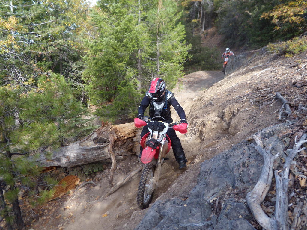
Two systems, two different characters. Stonyford's Grindstone District is the headline: 200-plus miles across 53 numbered trails and roughly 90,000 acres. Ratings are systematically undergraded. Blue trails ride like black diamonds: rocky, off-camber, cliff-edge single-track with creek crossings that punish mistakes. Trail 36 (Steam Donkey) is the standout: exposed cliff-edge line with a century-old steam donkey engine visible in the hillside below. Both systems rank among the best moto riding in California.
Stage at Stonyford for the east system; Middle Creek Campground for the west. Upper Lake runs 135-plus miles through the south basin plus 33 miles of northern trails open year-round. Middle Creek is the beginner and family zone. A 40-mile designated corridor connects both systems east to west for a full cross-forest ride day. The south basin closes annually May 18 through September 8. Both systems close after significant rain to protect trail surfaces. Check conditions before heading out.
Both systems close temporarily during and after significant rain events to protect trail surfaces. Stonyford closes more frequently. Check status before heading out.
Hull Mountain
Hull Mountain at 6,873 feet delivers a full 360-degree view across the Coast Ranges. South is Lake Pillsbury and Gravelly Valley. East runs toward Snow Mountain and the Sacramento Valley. On a clear day in fall you can pick out the Pacific to the west. The fire lookout is gone but the concrete piers and the wooden summit sign are still standing.
Drive M1 north from the Pillsbury Basin and follow the signed Hull Mountain spur. The road climbs through oak woodland and into mixed pine before narrowing on the final approach. AWDs and Crossovers should stay left near the top to avoid the rock garden on the driver's right. Budget 45 minutes from the Pillsbury area to the summit. Exposed and windy in late fall; snow closes the upper road November through April most years.
Snow closes the upper section November through April most years.
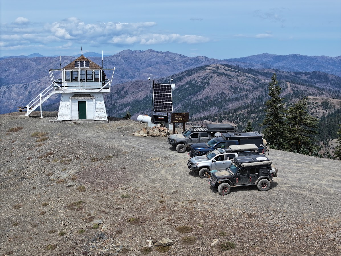
Anthony Peak Lookout
Anthony Peak is the highest point in Mendocino County at 6,954 feet and the last staffed fire lookout in the forest. The lookout crew surveys the western half of the forest daily during fire season. On a clear day the view runs from the Pacific in the west to Lassen in the east. After dark it is the best stargazing site in the forest: Bortle Class 2, 360 degrees of unobstructed sky, above the valley haze. The Anthony Peak lupine grows here and nowhere else on earth.
The road to Anthony Peak branches off the northern forest corridor. Stock 4x4 and most AWD crossovers handle it fine in dry conditions; the final mile is rougher. The lookout is occupied during fire season (typically May through October). The summit area is open but give the cab space. September and October give the clearest skies and most stable weather. Snow closes the upper road November through April most years.
Snow closes the upper section November through April most years.

M6 Game Refuge Corridor
The Game Refuge is a protected zone where hunting has been prohibited for decades and the wildlife reflects it. Bear sightings are more common here than anywhere else in the forest; a mama bear with cubs at Horse Creek Camp is a routine report from campers. The road runs through open meadows and oak corridors above the Eel River headwaters, with long ridge views and almost no traffic midweek.
Drive M6 west from the M1 junction in the upper forest. Horse Creek Camp is the logical base: sites on the Eel headwaters with good shade and almost always available. Move early morning or at dusk for the best wildlife activity. The corridor runs about 20 miles through the refuge. Take M61 back to M1 — from there you can head south back to Lake Pillsbury or continue north toward the Black Butte River. No technical driving required, but the road narrows in sections; slow down for oncoming vehicles.
One of Mendocino NF's most rewarding and undervisited corridors.
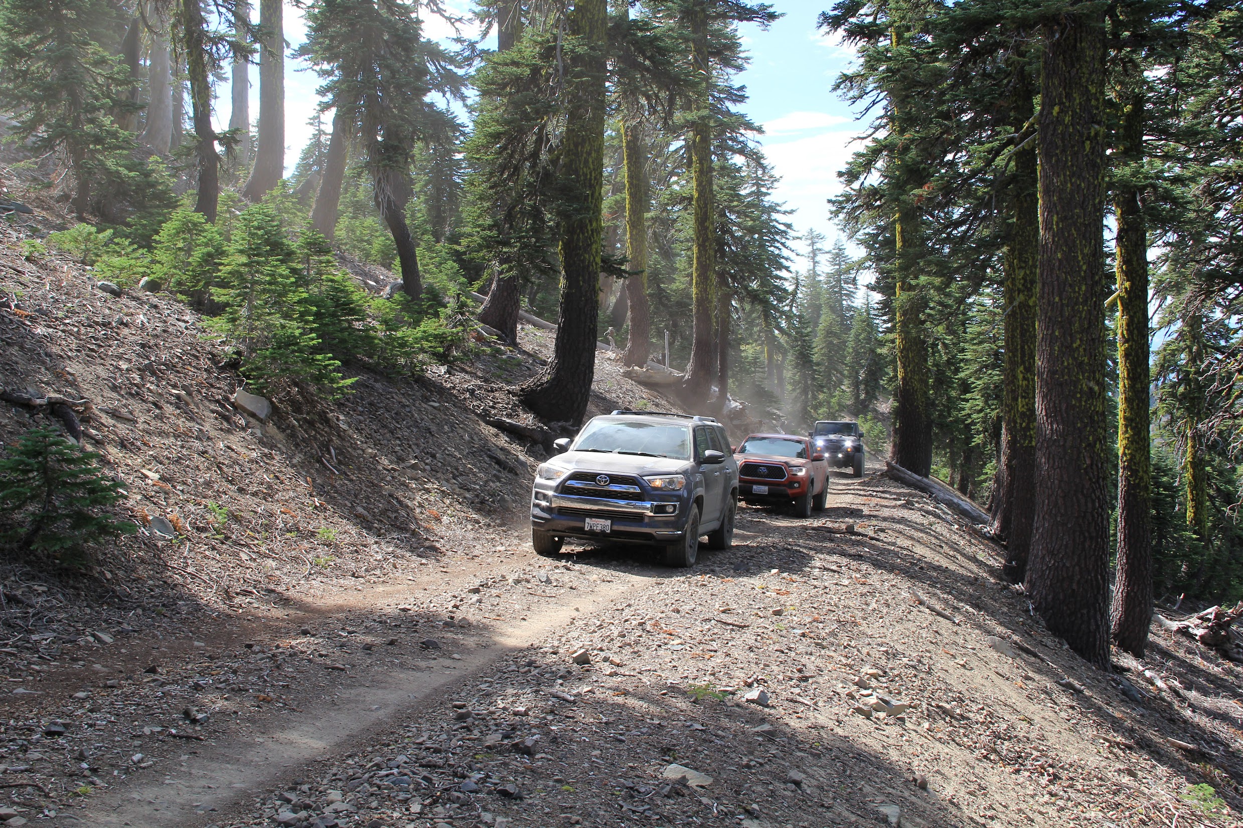
Mendocino is the only national forest in California with no paved through-road. Every route into and through the interior is graded dirt or gravel. That's what keeps the crowds thin. Most of the primary corridors are wide and well-maintained, manageable for a stock AWD crossover in dry conditions. Roads narrow and roughen as you push into the backcountry, and the Hull Mountain spur and a handful of northern routes add some challenge, but nothing on the main network demands lockers or skid plates. Conditions shift fast with weather. Routes that are straightforward in September can be impassable by November. One logistics note that matters: the Soda Springs store at Lake Pillsbury closed in early 2026, taking out the only mid-forest fuel stop. Carry extra fuel for any M1 traverse.
M1
DirtThe primary north-south spine of the forest. Runs from Upper Lake in the south through the Pillsbury Basin, past Hull Mountain, along the Black Butte and Eel Rivers near Black Butte River Ranch, and up to the far northern section near Indian Dick Work Station. Connects the major hubs: Middle Creek Campground and OHV Staging Area, Pillsbury Basin, Hull Mountain, and the confluence of the Black Butte and Eel Rivers. The backbone of any Mendocino trip and the route the BDT follows.
FH7 / Hwy 162
DirtThe major east-west connector on the northern end. Hwy 162 transitions to FH7 at the forest boundary. Wide graded gravel from Covelo westward. The primary gateway from the east and the route that gets you out to the Black Butte River Ranch area.
M10
DirtEast-west connector crossing the middle of the forest, linking the western side to the Letts Lake area and connecting into the greater Stonyford trail network to the south. One of the few roads that traverses the full width of the forest.
M6
DirtRuns through the Game Refuge, one of the most scenic corridors in the forest. Follows the headwaters of the Eel River with riverside camp access along the way. See Anchor Experiences.
M3
DirtConnects the Bear Creek area and winds west of Snow Mountain and St. John Mountain before joining M6. One of the lesser-traveled M roads — sees less traffic than M1 or M10 and gets less regular maintenance to match. Downed trees across the road in early spring are common after winter storms; clear it first before committing to a through-route. Good option for anyone wanting to string together a Bear Creek to Game Refuge loop with real solitude.
County Road 301 / Elk Mountain Road
DirtThe primary western gateway. The most common entry route. Hwy 101 to Ukiah, east through Potter Valley, into the forest toward Lake Pillsbury. Transitions to dirt once you cross the bridge past Potter Valley. Where most first-timers come in.
M Roads (M4, M8, M61, etc.)
DirtThe numbered M roads are the secondary network threading the full forest: graded dirt, generally wide enough for a truck, and AWD-appropriate in dry conditions. They branch off the primary corridors (M1, M6, M10) into draws, ridge runs, and basin connectors. Vary by season: passable for most rigs in summer, soft and sometimes impassable after rain.

Mendocino Backcountry Discovery Trail
↗ OTG GuideThe original California BDT, first put together in the mid-1990s, more than a decade before the KTM Backcountry Discovery Routes. Runs the full length of M1 from Upper Lake north to Covelo, passing through Hull Mountain, Bald Mountain, and the Black Butte and Eel Rivers. Wide dirt and gravel the whole way. Strong introductory overland route in California. Technical rating averages 2, peaks at 3.
Mendocino Grand Circuit
↗ OTG GuideThe full exploration of the forest. Covers all four corners including the remote northern boundary, the Game Refuge, the Eel River corridor, fire lookouts, and Hull Mountain. Everything the BDT hits plus deep into the edges most people never reach. Mostly soft-roading with a few steeper and rutted sections. Technical rating averages 1 to 2, peaks at 3.
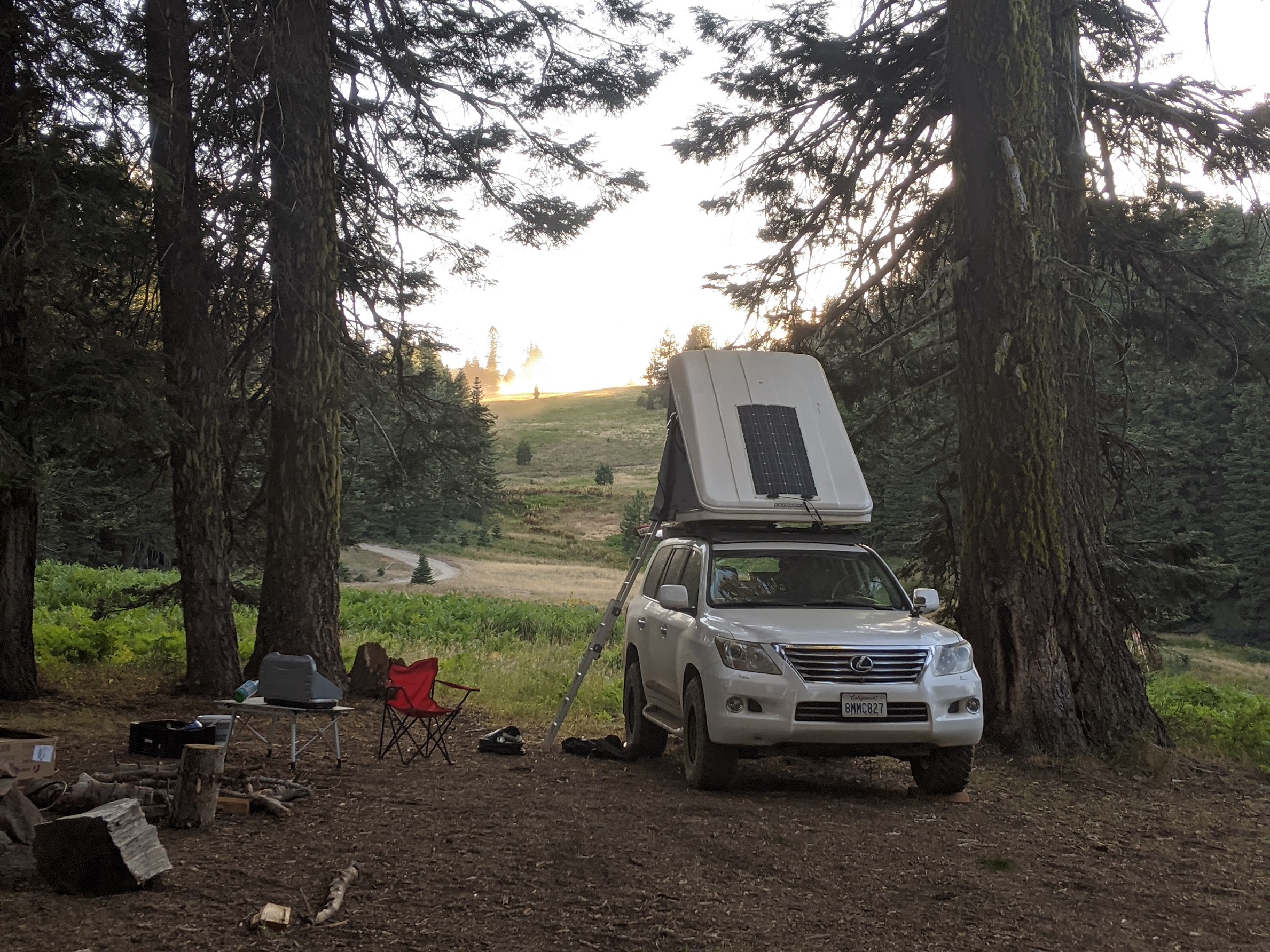
Dispersed camping is permitted throughout most of the forest with no fee, no reservation, and no permit required, same as most national forests in California. The difference here is the sheer amount of road to explore. The best dispersed corridors in the forest are M1 between Hull Mountain and the Black Butte River confluence and M61 between M1 and M6. You're above 4,000 feet, the road is wide enough to pull a rig off, and once you're set up you're unlikely to see another person. Little Doe, Howard Lake, and Hammerhorn Lake are the named primitive camps worth knowing in this stretch. Further south, the Lake Pillsbury basin fills up on weekends from May through Labor Day, so expect company. The Eel River Campground at the Middle Fork and Black Butte confluence is a favorite for overlanders running the BDT or Grand Circuit and doubles as river access.
Favorite Dispersed Spots
Pillsbury View
Exposed ridgeline camp just over 5,800 ft with a full panorama of the Pillsbury Basin, the southern forest, Snow Mountain, and the Coast Ranges to the west and south. One of the highest accessible dispersed sites in the forest. Bring a star chart. The sky here is exceptional.
Skunk Rock
A favorite dispersed pull-off in the northern forest with good access off the main corridor.
Eel Riverfront Camp
Riverside dispersed camp right on the Eel. Walk-to water access all summer.
Horse Creek Camp
Camp in the middle of the game refuge right along the headwaters of the Eel River.
Ridge Camp (Anthony Peak)
Exposed ridgeline camp with coast range views in every direction. On a clear day you can see the Pacific and Lassen Peak from camp. Dark skies are excellent at this elevation, well clear of any town.
Developed Campgrounds
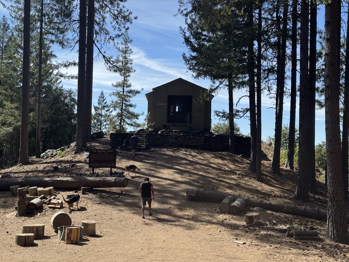
Pine Mountain Lookout
Historic 1933 fire lookout, converted to aircraft observation post during WWII. Sleeps up to 6 on bunk beds and cots, with sweeping 180-degree views west over the Coast Ranges. $50/night, 2-night minimum, open May–October. High clearance recommended on FR 17N23 and 18N05. Books out months in advance. Reserve well ahead.
📅 Reserve on Recreation.govOak Flat Campground
Best in the shoulder seasons. Elk graze throughout Gravelly Valley, especially mid-week when the crowds are gone. Fee required.
Board Tree Campground
A free campground with expansive views of the mountains to the south and west. Quieter than the lake campgrounds and a good base for the surrounding road network.
Bear Creek Campground
More dispersed camp than traditional developed campground. Sites spread out through good tree cover with solid shade throughout. Down by the equestrian area the spots open up into wide, flat clearings that work well for larger groups or rigs with trailers. Equestrians rarely camp there. Bear Creek runs alongside and stays cold enough to cool off in through the summer months. Pit toilet on site. Access requires crossing the Rice Fork: easy in summer when it's running around 12 inches, but deep and fast during winter and early spring snowmelt. Do not push through in high water.
OHV & Moto Trails
Two separate systems, each worth a dedicated trip. The Stonyford OHV area (Grindstone Ranger District) covers 200-plus miles across 53 numbered trails and roughly 90,000 acres. Ratings run green, blue, and black, but riders consistently find the real difficulty runs harder than posted. What's labeled blue tends to ride like a black diamond. Rocky, off-camber, steep in places, with creek crossings and some serious single-track. Trail 36 (Steam Donkey) is the standout: cliff-edge single-track with a historic steam engine visible in the hillside. On the west side, the Upper Lake system runs 135-plus miles through the south basin plus another 33 miles of northern trails that stay open year-round. Middle Creek is the beginner and family zone, with more forgiving terrain and good staging. A 40-mile designated corridor connects both systems east to west. Note: the south basin closes annually May 18 through September 8.
Lakes, Rivers & Swimming
The Eel River below Scott Dam is the move for river swimming. Two zones accessible by 4x4: near the old Soda Creek Store and near the Potter Valley bridge, where the river widens across clean gravel bars. Deep holes, summer water temps in the low 70s, near-zero traffic midweek. June through early July is the window before temperatures climb. Further north, the confluence of the Black Butte and Eel Rivers holds additional swimming holes that see even less traffic — a good option when the Scott Dam stretch is busy. Lake Pillsbury is the main flatwater destination for paddling and shore camping. Best before the water warms in July. August and September can bring blue-green algae blooms that make swimming unsafe. Check mywaterquality.ca.gov before going in. Stony Creek Falls on the east side has a clean plunge pool, one of the more reliable named swim spots in the forest. Kayak and canoe at Pillsbury; SUP on the calmer Eel stretches below the dam when flows allow.
Dark Skies & Stargazing
Mendocino National Forest sits in a Bortle Class 2 zone, the second darkest classification on the scale, shared by only a handful of California sites. At Class 2, the Milky Way casts visible shadows and naked-eye limiting magnitude clears 7.1. Hull Mountain and the M1 corridor north toward the Black Butte River are the standout spots: ridge-top above 4,000 feet, long views, nothing blocking the sky. Anthony Peak at 6,958 feet adds elevation and a full 360-degree horizon above the valley haze. Skunk Rock is a favorite dispersed camp for dark sky nights in the northern forest. Summer and fall deliver the clearest nights. Spring is hit or miss.
Fishing
Lake Pillsbury is the best bet in the forest. CDFW stocks rainbow trout each fall and spring, and the largemouth bass fishery is solid in spring. Horseshoe Gulch and the Rice Fork arm are the productive spots. Letts Lake at 4,500 feet is a solid secondary option: smaller and quieter, holds trout well through summer, and worth building into any trip to the eastern side of the forest. Plaskett Meadows has a small seasonal pond that produces fish; not the destination Pillsbury or Letts are, but people catch trout there. The Eel River within the forest between Potter Valley and Lake Pillsbury is landlocked above Scott Dam, which has blocked anadromous fish since 1921. What you're fishing for is resident rainbow trout with complicated PG&E-fenced access. The real Eel steelhead fishery is well downstream near Fortuna, outside the forest. PG&E submitted dam surrender paperwork in 2025, with removal targeted for 2028. When the dams come out, the lake drains and a free-flowing fishery opens up eventually. That's years away.
Hiking
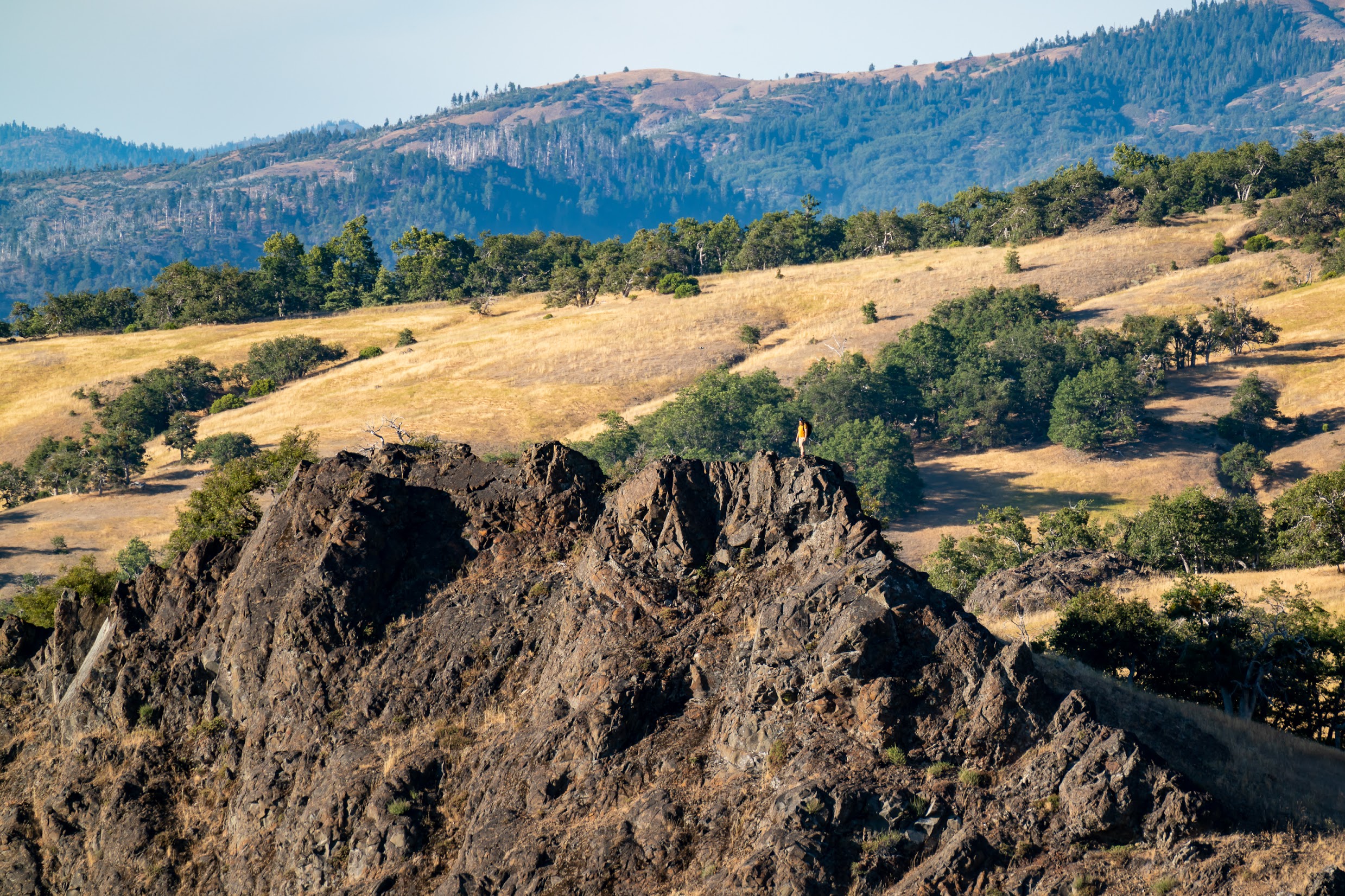
Mendocino NF is not a hiking destination. The roads are the draw, not the trails. Snow Mountain Wilderness has routes but they're unremarkable by Northern California standards. The one trail worth making time for is Bloody Rock: a 4.8-mile out-and-back to a basaltic outcrop above the upper Eel River canyon. The name is literal. In the fall of 1859, a group of Yuki people were cornered here by armed settlers, with sheer drops on three sides and nowhere to run. Between 30 and 65 people died at this site.
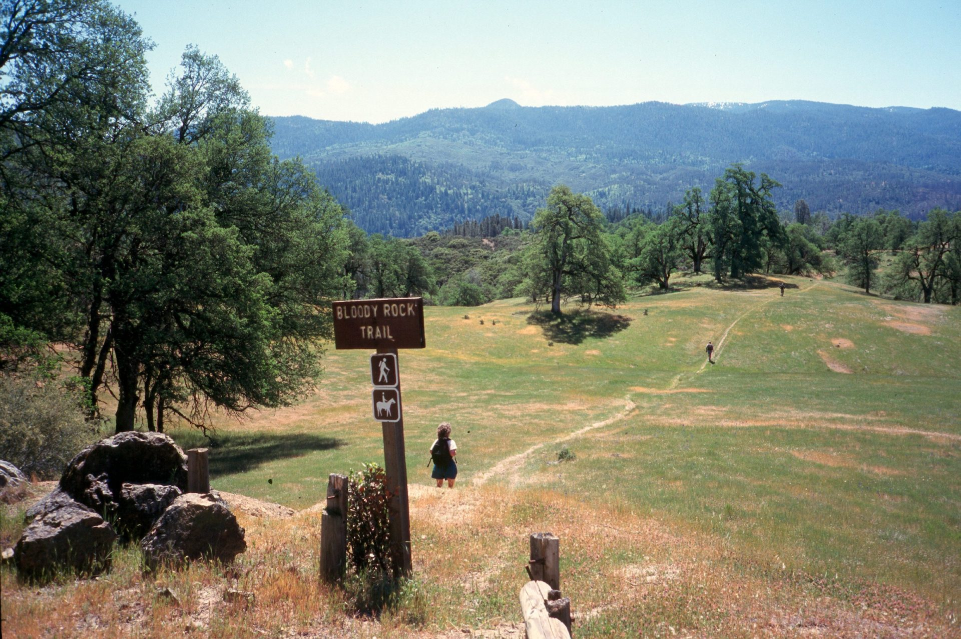
Bloody Rock
A basaltic promontory above the upper Eel River canyon, with sheer drops of 150 feet or more on three sides. In the fall of 1859, somewhere between 30 and 65 Yuki people from the Onkolukomno'm band (members who had fled the Round Valley Reservation) were cornered here by a group of armed settlers. The precise events are disputed. Every account that survives came from the perpetrators. One version says those trapped chose to jump rather than be captured. Historians now believe they were more likely forced off the edge or executed elsewhere on the rock.
The name is not poetic. It is a record. The blood that gives this place its name was spilled in 1859, and the site has carried that name ever since. It sits within the broader context of the Round Valley Settler Massacres of 1856–1859, a series of organized killings, partially funded by the California state legislature, that reduced the Yuki population from somewhere between 6,000 and 20,000 people to roughly 300 within a single decade.
The site is accessible via a 4.8-mile out-and-back hike from the upper Eel River canyon.

James Hull & The Grave on the Summit
James Hull was among the first American settlers to push into the upper Eel River country of Mendocino County, arriving in the early 1850s. He ran cattle across the high ridges of what is now the forest's southern interior, country that was barely mapped and far from any town or help.
Hull died in 1856. His grave remains on the summit ridge that carries his name at nearly 6,900 feet, a simple marker that has outlasted the homestead, the cattle operation, and most memory of the man himself. It is one of the more remote burial sites in Northern California you can still drive to.

Gravelly Valley: Polo Fields & Hollywood
Before the National Forest absorbed it, Gravelly Valley was someone's idea of a good time. The Pillsbury Ranch, a sprawling private operation that occupied the valley floor in the early 20th century, installed polo fields where the meadows run flattest. Jackie Gleason and at least one member of the Wizard of Oz cast (the story most often names the actor who played the Tin Man) were among the Hollywood figures who made the long haul north from Los Angeles.
They came to play polo, ride horses, and party well outside the reach of the studio press. It was the kind of place that worked precisely because it was too far away for most people to bother with. The polo fields are gone now, reclaimed by the same grass the Tule elk graze on every October.

The Yuki People
The Yuki people lived in and around Round Valley and the upper Eel River headwaters for at least 10,000 years before contact. Their population was somewhere between 6,000 and 20,000 in 1854. By 1864 it was roughly 300.
The Round Valley Settler Massacres of 1856 to 1859 were organized and partially funded by the California government. The state legislature appropriated money to pay a mercenary expedition that killed more than 280 people in six months alone. The Round Valley Indian Tribes, headquartered in Covelo at the forest's edge, carries the living legacy. The Nome Cult Trail, which passes through the forest above 6,000 feet, was the forced march route used in 1863 to relocate 461 Concow Maidu to Round Valley. Only 277 arrived.
The Ultimate NorCal Adventure | The 300+ mi Mendocino Grand Circuit
Overlanding
Overlander's Guide: Mendocino Backcountry Discovery Trail
Overlanding
Running the Mendocino BDT
Overlanding
Winter Truck Camping in Mendocino NF
Camping
Waking Up Surrounded by Elk
Wildlife
Most trails are open year-round with no gates. High-elevation routes above 4,000–5,000 ft typically get snowed in and become impassable December through March. Some years Hull Mountain and Anthony Peak remain accessible into December. Check conditions before committing.
The Soda Springs store at Lake Pillsbury closed in early 2026. It was the only mid-forest fuel stop. Carry extra fuel for any M1 traverse or long-distance exploration. Covelo has a gas station about 20 minutes from Black Butte River Ranch in the northern forest, accessible via Hwy 162.
Two significant fires have burned through parts of the forest in recent years (August Complex 2020, Ranch Fire 2018). Some areas carry heavy deadfall and remain under closure. Check current closure maps before finalizing your route.
Blue-green algae blooms hit Lake Pillsbury and sections of the lower Eel in late summer, typically August through September. Check the state HAB tracker at mywaterquality.ca.gov before swimming or paddling.
Fire restrictions are typically active June through October. Check Mendocino NF alerts before departure.
A persistent landslide north of Eel River Station currently blocks the full north-south M1 loop. The Espee Ridge Road bypass near the Doe Lake turnoff adds about 3 miles. Check current conditions before the trip.
OHV trails at both Stonyford and Upper Lake close temporarily during and after significant rain events to protect trail surfaces. Check current status before heading out, especially in winter and spring.